


Description
Platinum+ charts include all the content of Navionics+, enhanced with additional viewing options, including Relief shading, Satellite Overlay with SonarChart™ Shading, 3D View and Panoramic Photos.
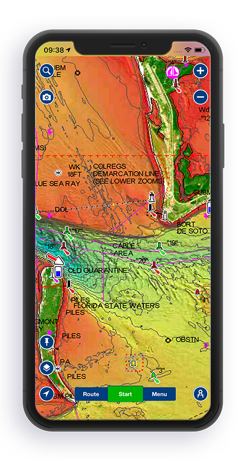 Preview Relief shading in your area of interest on the Boating app
______________________________________________________________________________________________________________________________________________________________
> The Navionics subscription
A one-year subscription to Daily Updates and advanced features is included when you purchase any new product.
After a year, you can renew at a discounted price.
> Charts & Updates
- Nautical Chart - comprehensive charts derived from multiple official, government and private sources, displayed in a familiar look and feel
- SonarChart™ - innovative 1' (0.5 m) bathymetry charts created using Navionics proprietary systems
- Community Edits - useful local knowledge from edits made by users of the Navionics Boating app
Daily Updates - Up to 5,000 updates every day
> Advanced features
- Dock-to-dock Autourouting - start your trip with a suggested route
- SonarChart™ Live - create your own maps
- Advanced Map Options - customize your view
- Plotter Sync - plan on mobile, go on plotter!
> Overlays
- Relief Shading - for an easy-to-interpret, clearer view of bottom structure. We use the best data available from our sources. In some cases, high-resolution data is mixed with low-resolution data to produce a more complete image. Check Coverage
- Satellite Overlay with SonarChart Shading – for an enhanced awareness above and below the water. Check Coverage
> Platinum additional viewing options
- 3D View - to highlight key features
- Panoramic Photos - to get a better sense of your surroundings
> Coverage areas
Choose from very large coverage areas (Large) to more localized chart cuts (Small).
> Compatibility
Check compatibility of Navionics content and features with your GPS chartplotter.
| Navionics+ | Platinum+ | |
|---|---|---|
| Nautical Chart | • | • |
| SonarChartTM | • | • |
| Community Edits | • | • |
| Daily Updates | • | • |
| Dock-to-dock Autorouting¹ | • | • |
| SonarChartTM Live | • | • |
| Advanced Map Options | • | • |
| Plotter Sync | • | • |
| Satellite Overlay with SonarChart ShadingView Coverage | • | |
| Relief Shading View Coverage | • | |
| 3D View² | • | |
| Panoramic Photos | • |
Navionics Platinum+ LARGE R...
Australia N and WGet notified when this item is back in stock
Press & drag to view